The construction and ongoing use of an oil location for drilling or production operations has the potential to impact soil in different ways including:
- Disturbance of the soil profile,
- Reduction of organic matter,
- Destruction of soil structure,
- Compaction of topsoil and subsurface soil,
- Increased soil erosion, and a
- Reduction in soil fertility.
Soil is the unconsolidated mineral or organic matter on the immediate surface that serves as a natural medium for the growth of land plants. According to the United States Department of Agriculture Natural Resource Conservation Service (USDA-NRCS) soil performs vital functions that sustain plant and animal life, regulates water flow and filters and buffers pollutants.1NRCS, What is Soil?, accessed March 27, 2023, https://www.nrcs.usda.gov/resources/education-and-teaching-materials/what-is-soil.

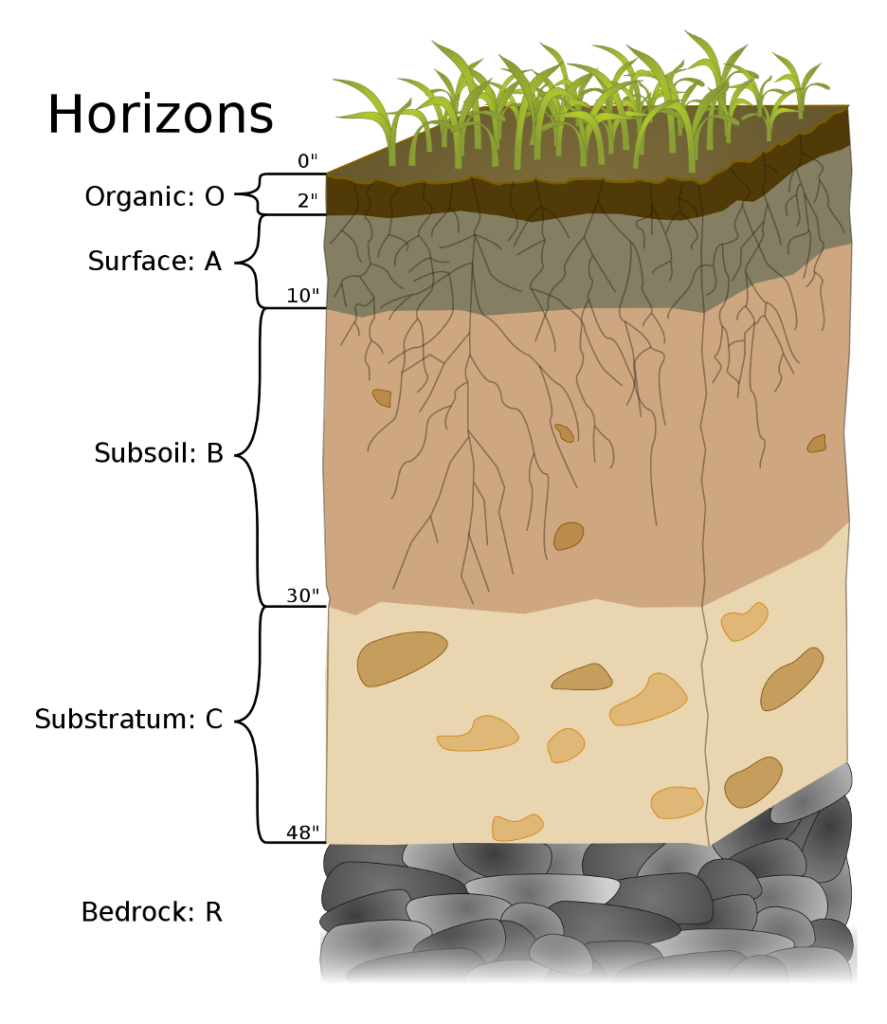
Soil is divided into different horizontal layers, or horizons that have different compositions the farther they are from the surface, giving the soil a vertical profile. For example, topsoil (Surface: A in the diagram), which is the topmost horizon or layer of soil, contains higher levels of organic material and biological activity. Topsoil includes all plant life and its root structure. Roots and associated bacteria play an important role in many biological processes such as nitrogen fixing. Subsoil (Subsoil: B in the diagram), the layer under topsoil, is comprised of a mixture of sand, silt, and clay, a minor percentage of organic matter, and may also contain a small amount of rocks. Beneath these layers, poorly weathered rocks may accumulate soluble compounds in Substratum: C, with the lowermost horizon comprising the Bedrock: R where hard rock is present that cannot be excavated by hand.2Soil Horizon, Wikipedia, accessed March 27, 2023, https://en.wikipedia.org/wiki/Soil_horizon

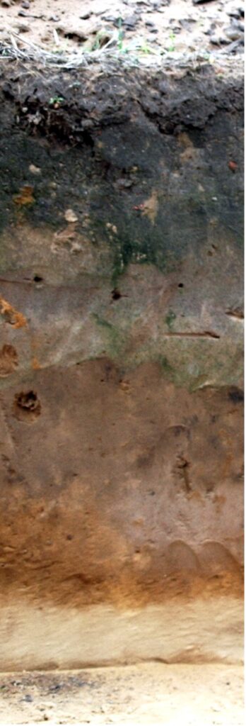
During the construction of roads and production sites, topsoil and subsoil may get mixed resulting in the rapid breakdown of organic material leading to decreased soil quality. To avoid this degradation, operators should salvage, segregate, and stockpile topsoil horizons separately from subsoil horizons during construction and then replace all horizons to their original position within the soil profile during reclamation. In many cases soil horizons can be identified by obvious physical features, such as color, organic content, odor and texture. Soil texture is identified through analysis of the particle size distribution of clay, silt and sand. The Soil Texture Triangle (see figure) is commonly employed for this analysis.

Beyond profile, texture and organic content, soil structure is another quality that affects soil quality. Soil structure is the arrangement or combination of sand, silt, and clay particles into larger units called soil aggregates. These aggregates contain pore spaces for the movement of air and water. Soil structure affects permeability, aeration and water holding capacity, all of which affect soil’s ability to nurture plant life. Oil and gas operations can heavily influence soil structure. As heavy machinery pushes the soil particles together, compaction results and diminishes the pore spaces. Soil with reduced porosity is more susceptible to erosion because water will flow over compacted soil rather than soaking into it. During site stabilization and reclamation operations, aeration or decompaction is necessary to introduce porosity back into soil that has been negatively affected by mechanical operations. Restoration of topography can compensate for soil erosion, however, additional erosion control practices such as mulching, use of flexible growth media, reseeding or application of erosion control matts may be necessary to minimize soil erosion while revegetation is in progress.
Another aspect of soil quality is fertility. Plants need seventeen (17) elements or nutrients to grow, and the soil provides14 of these 17 elements (see table). Certain agronomic parameters such as pH, Electrical Conductivity (EC) and the Sodium Adsorption Ratio (SAR) also affect plant growth. The soil’s pH has a significant effect on soil fertility because it dictates the solubility of nutrients in the soil. Soil EC is a measure of the salinity of soil and is used as an indicator of nutrient availability and loss. It can also provide information on the soil texture, and available water capacity. Soil salinity (EC) affects many issues related to agronomics and site revegetation such as crop yields, the suitability of the soil for certain crops, the amount of water and nutrients available for plant use, and the activity of soil micro-organisms.3NRCS, Soil Electrical Conductivity, Soil Health Guides for Educators, accessed March 27, 2023, https://www.nrcs.usda.gov/conservation-basics/natural-resource-concerns/soils/soil-health/soil-health-educators-guide. Soils with elevated levels of exchangeable sodium (Na) and low levels of total salts are called sodic soils. Sodic soils may impact plant growth and sodic soils tend to develop poor structure and drainage over time because sodium ions on clay particles cause the soil particles to disperse. Sodium levels in soil are often reported as the sodium adsorption ratio (SAR). This is a ratio of the amount of cationic (positive) charge contributed to a soil by sodium, to that contributed by calcium (Ca) and magnesium (Mg).4J.G Davis, R.M. Wascom, T.R .Bauder, 2012, Managing Sodic Soils, Fact Sheet No. 0.504, Colorado State University Extension, https://extension.colostate.edu/docs/pubs/crops/00504.pdf.
Mixing soil horizons can substantially impact the concentration of elements available and the pH, EC and SAR of the soil. During reclamation, operators may be required to restore nutrients, pH, EC and SAR back to pre-operations levels. The only way to achieve this is through a robust soil testing and analysis procedure.
Soil Nutrients
Primary Macronutrients
| Element | Average Concentration in Plants | Ionic form, plant available |
|---|---|---|
| Nitrogen, N | 1.5% | NO₃⁻, NH₄⁺ |
| Phosphorus, P | 0.2% | HPO₄²⁻,H₂PO₄⁻ |
| Potassium, K | 1.0% | K⁺ |
Secondary Macronutrients
| Element | Average Concentration in Plants | Ionic form, plant available |
|---|---|---|
| Calcium, Ca | 0.5% | Ca²⁺ |
| Magnesium, Mg | 0.2% | Mg²⁺ |
| Sulfur, S | 0.2% | SO₄²⁻ |
Micronutrients
| Element | Average Concentration in Plants | Ionic form, plant available |
|---|---|---|
| Boron, B | 20 ppm | B(OH)₃, B(OH)₄⁻ |
| Copper, Cu | 6 ppm | Cu²⁺ |
| Chlorine, Cl | 100 ppm | Cl⁻ |
| Iron, Fe | 100 ppm | Fe²⁺, Fe³⁺ |
| Manganese, Mn | 50 ppm | Mn²⁺ |
| Molybdenum, Mo | 1 ppm | MoO₄²⁻ |
| Nickel, Ni | 0.1 ppm | Ni²⁺ |
| Zinc, Zi | 20 ppm | Zi²⁺ |
One of our experts explains the fine points of soil quality and accepted procedures for soil testing and analysis.
Transcript
Soil Management Related to Oil and Gas Operations – David Messersmith – Penn State
Oil and gas operations have the potential to impact soil in a variety of ways. Generally, an operator’s goal is the extract petroleum from a field with as little permanent alteration to the surface as possible. This means operators should assess and document both the physical properties of soil and the soils’ fertility before excavation and after site restoration. The physical properties of soil encompass both soil texture and structure. Soil is divided into horizontal layers that may have different properties. Through site preparation, these layers can get mixed. Top soil, which usually has higher levels of organic material and biological activity, may get mixed with subsoil. Mixing and moving these layers of soil also introduces oxygen, which causes the rapid breakdown of organic matter. In theory, if farmland, this may lead to reduced crop yields. So operators need to identify and reserve top soil when excavating and then spread the top soil back on the surface when the site is reclaimed.
Another way the physical properties of soil are compromised during site preparation is through destruction of the soil structure. Soil structure is the arrangement of sand, silt and clay particles into larger units called soil aggregates. These aggregates contain pore spaces for the storage and movement of air and water. Soil structure determines physical characteristics, such as aeration, permeability and water holding capacity. Soil structure can be affected by heavy equipment or earth moving activities that compact the soil. Compaction pushes the soil particles together, shrinking or eliminating the pore spaces within soil aggregates. Compacted soil is more prone to erosion, as water will tend to run off the site, rather than infiltrate into the soil. Good soil structure is an essential quality for plant growth. It encourages better seedling emergence, more root growth and better overall re-vegetation, than sites where the soil structure has been destroyed or severely impacted.
Soil fertility is the other half of the equation. Fertility refers to the ability of the soil to provide the correct balance of nutrients required for healthy plant growth. 17 elements are considered essential for plant growth, 14 of which are only available to the plant through the soil. Beyond these elements, pH is the most important measurable chemical property because pH dictates the solubility of the nutrients in soil solution.
So how do operators insure that soil structure and fertility are impacted as little as possible? The first step is testing. Without knowing pH and nutrient levels in the soil, we don’t know whether lime or fertilizer is needed and at what application rate. A comprehensive soil testing program will help the operator identify current nutrient levels and then allow them to systematically amend the soil, so that it provides the correct balance of nutrients for plant growth once the site has been restored. The first step in testing is defining sample areas. Most sites have variations in soil structure and fertility. A single site may have multiple sample areas. Sample areas should have the same soil texture, color, slope, drainage and past management. Operators should develop maps of the site and keep records of where soil samples were taken so that soil test results can be identified back to the area they represent. Depending upon the size and nature of the sample area, 15 to 20 core samples should be taken within each sample area and mixed together to create a representative sample.
The samples are then sent to a lab for analysis. There’s a great deal of variability in soils across North America, so it’s a good practice to choose a local laboratory. Local testing facilities are calibrated to the soils within their region and are generally the best option for testing and providing lime and fertilizer recommendations for local soils. By completing proper testing and documentation of the native soils on a site before work begins, we are better able to mitigate the impact of operations and maintain and restore the site.
Images: “Compaction” by Dan Brockett, Penn State University


