Geologic Mapping
Geologic maps are a critical part of the oil and gas exploration and development process. These maps describe the distribution of rock units and strata on the surface of the earth. They also contain a wealth of information about the three dimensional structure of these units.
Traditionally, geologists developed geologic maps based solely on surface mapping. By studying the characteristics and geologic structures of rocks on the surface, geologists were able to surmise certain things about what was going on at depth. Although modern technology allows us to look at what’s going on underground, field mapping has historically been the first step to exploring a potential field.

Geologic maps provide a quick glimpse at the geology of a region. Although oil and gas deposits are often too deep to be accurately located using a traditional geologic map alone, the map contains clues that allow geologists to decide which areas are worth investigating using more expensive remote sensing techniques.
For example, detailed knowledge of the thickness and composition of a certain rock layer can be gained by studying the layer where it intersects the surface. This knowledge can then be extrapolated to constrain layer thicknesses and characteristics at depth, which makes it easier to predict where oil and gas might occur.
Finding Your Way around a Geologic Map
Geologic maps contain so much information that they can seem overwhelming to the uninitiated. In this section we’re going to take a detailed look at a geologic map. By the end, you should have an understanding of the key parts of the map.
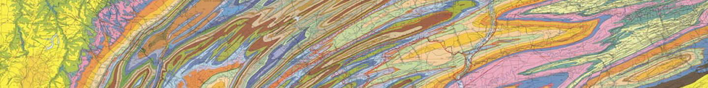
When you look at a geologic map, the first things you notice are probably the large blobs of color superimposed over the landscape. These blobs represent the surface exposures of various rock units. Although many rock layers are present beneath any given point, only the layer closest to the surface is shown on the map.
A bedrock geology map shows the surface exposure of each rock unit, ignoring anything that might be covering the rocks, including soil, glacial sand and rock deposits, and water. This is the most common type of geologic map, and the most relevant to oil and gas exploration.
In contrast a surficial geology map does not ignore unconsolidated deposits. Such a map might show soil types, sand dunes, or piles of rocks left by glaciers. A surficial geology map is not used in oil and gas exploration. However, since unconsolidated units often contain and transmit groundwater, these maps are a critical part of efforts to comply with environmental regulations.
Images: “Geologic Map of Pennsylvania” by Pennsylvania Department of Conservation of Natural Resources; “Topographic Mappers, Sonora, California” by USGS