Eight years after the DFW earthquakes, a 5.8-magnitude earthquake shook the town of Pawnee, Oklahoma.1TW, September 8, 2016, “Oklahoma’s M5.8 Earthquake Activated an Unknown Fault,” The Watchers, https://watchers.news/2016/09/08/oklahoma-s-m5-8-earthquake-activated-an-unknown-fault/ (accessed March 21, 2017). It was the largest in the state’s history and geologists in both industry and the government ultimately linked the incident to wastewater injection disposal by oil companies. As previously mentioned, induced seismicity typically does not rise above a magnitude of 3, so such a strong earthquake resulting from human activity came as a surprise.
Why did such a large induced earthquake happen in Oklahoma?
Mapping the aftershocks indicated that the earthquake occurred along a fault geologists were not previously aware of, and this raised the question: Would the earthquake, in fact, have happened without the wastewater injection?
Oil and gas operations, as well as wastewater disposal operations, are carefully planned to avoid faults. Additionally, these injection wells typically are very deep beneath the surface in order to avoid any possibility of contaminating freshwater aquifers. However, deeper disposal carries the tradeoff of disposing water in rock under greater stress and possibly more densely populated with faults. Let’s examine the particular geology that contributed to induced seismicity as a response to underground injection in this particular region of Oklahoma.
The Arbuckle Formation and its association with pre-existing faults
In Oklahoma, the Arbuckle Formation receives the overwhelming majority of wastewater injection from local oil and gas production. This is the deepest sedimentary layer in the area, about which far less is known than the hydrocarbon-producing layers above it. The formation stands out geologically as a prime destination for disposal fluids, as the formation itself is under-pressured and more readily accepts fluids than other layers with higher natural pressures. However, the Arbuckle is located just above the crystalline basement rock, the layer of the crust in which no sedimentary rock exists. This deep basement rock is under greater vertical stress than more shallow formations and contains many older, unknown faults, some of which may be in contact with the overlying Arbuckle. Fluid injection into the Arbuckle does affect the stress state of the formation itself, and may cause incremental changes to the stress state of other formations, which can trigger activation of previously inactive faults.
Mitigating induced seismicity risk in Oklahoma
Some groups argue that the best way to mitigate the risk of induced seismicity is to stop injecting into the Arbuckle. As part of a traffic light system approach, the Oklahoma Corporation Commission, in a series of directives between 2013 and late 2016, shut down some wells, prevented other new-well startups, and required reduced fluid injection volume in still other wells to mitigate fluid pressure increases in the Arbuckle.2Oklahoma Corporation Commission, 2016, Earthquake Response Summary http://www.occeweb.com/News/2016/11-23-16EARTHQUAKE%20ACTION%20SUMMARY.pdf (accessed March 21, 2017).
Some possible solutions for Oklahoma oil and gas operations, should the Arbuckle no longer provide a viable injection zone, are for companies to inject wastewater very far from production sites, to inject into shallower zones or to send the water to a treatment facility. All these alternatives to the Arbuckle have consequences. Restrictions themselves come at a cost to the energy industry. Some stakeholders argue that there are economic costs to Oklahoma as a whole because, according to one estimate, the industry is responsible for one in five jobs statewide.3Richard A. Oppel, Jr. and Michael Wines, 2015, April 3, “As Quakes Rattle Oklahoma, Fingers Point to Oil and Gas Industry,” The New York Times, https://www.nytimes.com/2015/04/04/us/as-quakes-rattle-oklahoma-fingers-point-to-oil-and-gas-industry.html?_r=2 (accessed March 21, 2017).
The U.S. Geological Survey responds to increased seismic activity
The U.S. Geological Survey (USGS), in response to increased seismic activity in places like Oklahoma thought to be related to human activity, has worked to better understand areas of induced earthquakes. The agency installs seismometers in areas of increased seismicity, provides hazard estimations, and uses numerical models to better understand seismic events. The USGS recently published a graphic that illustrates the dramatic rise in M3+ earthquakes in the central and eastern United States, coincident with the Shale Boom.4U.S. Geological Survey, 2022, March 9, “Induced Earthquakes Overview” https://www.usgs.gov/programs/earthquake-hazards/science/induced-earthquakes-overview (accessed January 1, 2023).
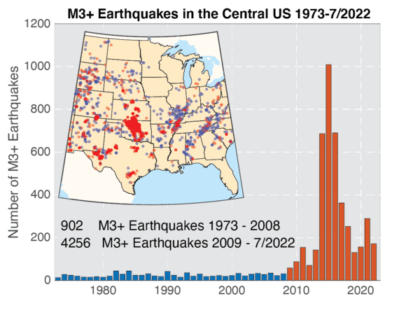
The USGS analysis illustrates that between 1973–2008, there was an average of 25 earthquakes annually of magnitude three and larger in the central and eastern United States. Since 2009, at least 58 earthquakes of this size have occurred each year, and at least 100 earthquakes of this size every year since 2013. The rate peaked in 2015 with 1010 M3+ earthquakes. Since 2015, earthquake rate has declined (e.g., in 2019, the number was down to 130 M3+ earthquakes). Nonetheless, this rate is far higher than the average of 25 earthquakes per year before 2009. Most of these earthquakes are in the magnitude 3–4 range—large enough to have been felt by many people—yet small enough to rarely cause damage. Damage has been caused by some of the larger events, including the M5.8 Pawnee we have discussed here that occurred in 2016.5U.S. Geological Survey, 2022, March 9, “Induced Earthquakes Overview” https://www.usgs.gov/programs/earthquake-hazards/science/induced-earthquakes-overview (accessed January 1, 2023).
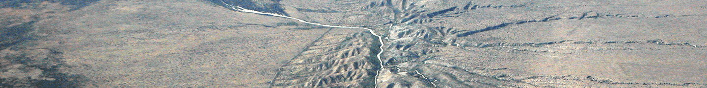
Images: “Faultfinder_48” by Doc Searls licensed under CC BY SA 2.0